 Grand
Marais Lifesaving Station
Grand
Marais Lifesaving Station
In the heyday of ship travel on Lake Superior, the United States Lifesaving Service operated five Lifesaving Stations along this part of Lake Superior's southern shore. If you have a day to spare and don't mind traveling the back roads of the U.P., you can visit four of the five sites. Your tour begins in Grand Marais and travels east as far as Crisp Point. Although little remains of any actual buildings, the tour will take you through some of the U.P.'s most beautiful forests and past several inland lakes, as well as a number of stops on Lake Superior. Take a picnic and enjoy!
Our thanks to: Mr. Paul Petosky, Michigan
Postal History historian and owner of Postmarks From the Past, for his assistance
and the use of photos from his personal collection; Mrs. Carol Taylor for the
use of photos from the Sprague Taylor collection of the Luce County Historical
Society; and the Crisp Point Light
Historical Society.
Grand
Marais Lifesaving Station
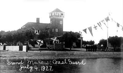
The Grand Marais Lifesaving Station was located at the west entrance to Grand Marais Harbor. It was erected and placed into commission in 1899. The most spectacular rescue at this station occurred on November 14, 1919, when the entire crew of 17 were saved from the stranded steamer H.E. Runnels. Four trips through a high and dangerous surf were necessary to bring all the crew to safety.
Many visitors assume that the current Ranger Station (site of the Maritime Museum) was built on the site of the old lifesaving station. Not so. The lifesaving station was across the road and faced onto the harbor. To view the old site, park in front of the Ranger Station and walk across the road behind the current Coast Guard Auxiliary building. You will see a large clear area surrounded by mature trees. This is where the building once stood. Little is left of the old lifesaving station except for some cement walkways and a few dock pilings in the water.
The Maritime Museum inside the Ranger Station is well worth a visit. You'll find artifacts from the lifesaving station and its crew, including a rare United States Life Savers Medal awarded to a station crew member for the Runnels rescue. Only five of these medals are known to be in existence today.
Deer Park Lifesaving Station
(Click here to view maps for all parts of this tour)
Driving directions: From Grand Marais, take H-58 east to Deer Park (appx. 17 miles; the road becomes County Road 407 at the Luce County line). To locate the site of the old station, go past the entrance to Muskallonge Lake State Park and continue appx. 1/4 mile east. You'll come to a large cleared area on both sides of the road. There are some logs placed on the north side to mark a parking area of sorts. If you park here and go down the trail to Lake Superior, you'll see the old cement sidewalks for the buildings. This was the site. For more detailed information and some photos, backtrack to the state park entrance and see the display board outside the park. One of the three sides is dedicated to the history of Deer Park and the lifesaving station.
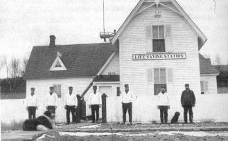 The
Deer Park lifesaving station (right) was located near the mouth of the
Sucker River, now shown as the Blind Sucker River on maps. The station
had several names over the years. It was first known as the Sucker River
Station when it was established in 1874, then the Muskallonge Lake Station,
and finally the Deer Park Lifesaving Station. It was also known as
Lifesaving Station Number 12 in its earlier days.
The
Deer Park lifesaving station (right) was located near the mouth of the
Sucker River, now shown as the Blind Sucker River on maps. The station
had several names over the years. It was first known as the Sucker River
Station when it was established in 1874, then the Muskallonge Lake Station,
and finally the Deer Park Lifesaving Station. It was also known as
Lifesaving Station Number 12 in its earlier days.
A switching station for all Coast Guard Telephone lines on the south shore of Lake Superior was installed at Deer Park, and a continuous watch was maintained the same as that at the more active stations. The coastline along this part of Lake Superior is quite isolated and the Deer Park crew made a number of spectacular rescues over the years. For more photos of the Deer Park station and one of the old school, click here.
Two-Heart River Lifesaving Station
Driving directions: From Deer Park, head south on H-37, which is the main blacktop road. A stop at the Deer Park Lodge along the way is worth it. There you will find more photos of the old Lifesaving Station and Deer Park sawmill (plus a good selection of ice cream bars). Approximately four miles south of the village, you will turn left on County Road 410 . There will be signs for Perch Lake and the Rainbow Lodge and canoe outfitters at the Two-Heart River. Travel approximately fourteen miles on County Roads 410 and 412. The roads to Rainbow Lodge are well signposted. There is a state forest campground and picnic area here, and it's a nice stopping point for a picnic lunch. Drinks, snacks, fishing equipment, and souvenirs are available at the store.
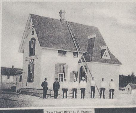 The
lifesaving station was placed into service in 1875. It was located
on the beach near the mouth of the Two-Heart River approximately 38 miles
north of Newberry. This station was considered one of the important
stations in the days of sailing vessels. As near as can be determined,
the crews of this station rescued 960 persons after it was placed into
commission.
The
lifesaving station was placed into service in 1875. It was located
on the beach near the mouth of the Two-Heart River approximately 38 miles
north of Newberry. This station was considered one of the important
stations in the days of sailing vessels. As near as can be determined,
the crews of this station rescued 960 persons after it was placed into
commission.
The buildings were torn down sometime after 1940. For a look at the lifesaving station in some interesting old photos, inquire at the store. The storekeeper has a small album he will show you. We have a photo of the foundations of the station in 1969. Click here.
The remnants of the station are visible in the concrete sections found on the sand. If you have a keen eye, you might want to try locating the old cemetery used by the station crews. Cross the footbridge and turn left. You'll need to go a few hundred yards up the hill. The cemetery is now marked only by shallow depressions where graves were located. (above photo courtesy of Paul Petosky)
Crisp Point Lifesaving Station
Driving directions: From the Two-Heart River, backtrack to County Road 412 and turn east (left). You will follow County Roads 412 and 414 past Little Lake (worth a visit, if only to see what may be the most remote phone booth in Michigan). The road to Crisp Point is signposted. Total trip from Two-Hearted River is about 15 miles. Don't be fooled by the gravel road - this is a county road and the lighthouse is easily accessible by car. You don't need four-wheel drive. And it's definitely worth the effort!
The Crisp Point Lifesaving Station was also known as Station 10 (Two-Hearted
River being Station 11 and Deer Park being Station 12). It was named Crisp
Point (sometimes referred to as Crisp's Point) after Christopher Crisp,
an early lifestation chief. The station was activated in 1876.
Crisp Point was particularly treacherous for ships, and in 1903 construction
of the lighthouse began. It was placed in operation in 1904.
The lifesaving station buildings had to be moved back from the shoreline
several times, due to the erosion of the sand.You can view more photos
of the Crisp Point Station, including one of a building being moved, by
clicking
here.
The buildings were razed by the Coast Guard in 1964, and only the light tower and a small attached service building remained. In November of 1996, a severe storm wrecked the service building and threatened the lighthouse with collapse. The Crisp Point Light Historical Society was formed to restore and preserve the light for future generations. Projects included hauling in tons of rock to place at the base of the light to help prevent further erosion, repainting the tower, and constructing a boardwalk. The tower is open and you can climb to the top for a magnificent view. We urge you to help the CPLHS in their efforts. The lighthouse site is staffed by CPLHS volunteers most days during the summer months.
We hope you enjoy your tour of the Lifesaving Station sites! Return to Grand Marais by backtracking along your route.